Not as famous as Waipio, but still beautiful and much more accessible on foot. It's a quick 15-20 min down a dirt trail with a fairly steep grade (be careful if it's raining). You end up on a black sand (and rock) beach. It has strong rip currents and the beach is sometimes covered with jellyfish; don't swim here. Expect to see a lot of people. If you head to the right at the bottom of the trail, you can walk for a bit up the valley, where there are often cattle and shorebirds. I saw a few mongeese. Don't go past the fence, which marks private land. The main trail actually continues across the back of the beach and up the opposite side of the valley into private lands. This trail is rather narrow and can be quite muddy, but it takes you into the next valley (Honokane Nui) where there will definitely be fewer people. Various books and web sites suggest that you get permission from Surety Kohala in Hawi before hiking into Honokane Nui. The walk back up to the parking area is fast but a bit steeper and tougher (it's 400+ feet in elevation) than you might expect from the easy walk down.
Directions: Go west from Waimea, but take a soft right at 250 rather
than going straight (which takes you to the coast). You cross the Kohala Mountains, with
spectacular views of the coast going north and of Mauna Kea returning. Follow
Kohala Mountain Rd; turn right on 270. This takes you through the little town of Kapaau; you can
stop for food/water here. Follow 270 to the end. There's a small parking lot but you can also
park on the side of the road ~100 feet up if it's full. The trailhead is at the end of the
parking lot. Heading back, it's easy to miss the turnoff---if you find yourself in Hawi, just
take 250 south (the signs should be marked Waimea).
Pu'u O'o Trail
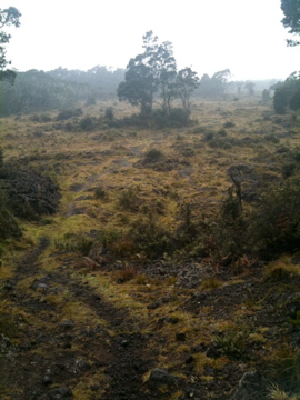
A beautiful hike off Saddle Road, closer to Hilo than Waimea (this trail has nothing to do with the one to the active Pu'u O'o vent). However, with the improvements to the Saddle Road, it doesn't take long to reach. The hike alternates between meadows (most of which were cleared for pasture) and small stands of native forest. In the forests there's a dizzying array of native (and non-native!) birds, with some reports of nene. A sign at the trailhead lists a bag limit for goats, sheep, and pigs, so watch out for these feral creatures. I turned around after ~ 2 miles at the end of a patch of forest at a big a'a field; the trail itself goes for a bit less than 4 miles. There it crosses the Power Line trail, which you can take back to Saddle Road (and then walk half a mile back to your car) for an improvised loop if you're in the mood for a longish hike. The Power Line trail has fewer patches of forest and more lava. Bring a jacket; it may drizzle or rain. I did the first part of hike with no issues in tennis shoes, but you might want hiking boots if you're planning to walk miles over a'a. Look for cairns or blue ribbons to mark the trail in the meadows, where it can be hard to follow. I didn't see a single other person on the trail.
Directions: Go south from Waimea, past the airport on your left. About 5-6 miles
down turn left onto the Saddle Road. The first few miles are still unimproved, so drive
carefully (past this point, most of the construction work is done and the road is high quality).
Expect to get stuck behind slow cars or trucks. Look for wild turkeys on the side of the road.
I'd recommend not speeding, especially near the military base and as you get closer to Hilo. The
trailhead is between mile markers 23 and 22, on the south side of the road, and is well marked
coming from Waimea. Despite what you will read, it is now legal in many rental car contracts
to drive on the Saddle Road. Obviously, if this concerns you check your own contract.